The plan will be a 3 day trip through the mountains of North Georgia along the 360 mile Georgia Traverse.
http://www.georgiaoverland.com/map.html
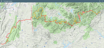
The Georgia Traverse is a collection of county, state and Forest Service roads that comprise a (mostly) off-pavement route across North Georgia. It is designed to be traveled east to west, beginning at Burrells Ford Road along the Georgia / South Carolina border. The Georgia Traverse visits North Carolina and Tennessee before ending at the Georgia / Alabama border. The total mileage of all paved and unpaved sections is 390 miles. I included a few alternate, off-pavement sections to explore along the Traverse. The total mileage includes the alternate sections, as shown in the map and represented in the download. However, roads not explicitly shown as part of the Traverse are not included in the mileage. Of the 390 total miles presented here, 226 miles are unpaved road surfaces consisting of gravel, dirt or both. Connecting the off-tarmac sections are 164 miles of pavement, with just over 40% of the paved miles found west of the Cohutta and Big Frog Wilderness Loop. Though I found limited opportunities for off-pavement connectivity in the western portion of the Traverse, I decided to include what I did find in an effort to offer a border to border travel experience across Georgia. -- Georgia Overland Website
Updated information on Road/Trail closures located here:
https://www.fs.usda.gov/alerts/conf/alerts-notices/?aid=45343
we will need to check these the day before we leave.
Can Leave Thursday Afternoon/Evening Noted with Green
Thursday
Dinner - Stop on the way up
Friday
Breakfast - Wayne - Sausage and Eggs
Dinner - David - Fajitas
Saturday
Breakfast - Banana Pancakes, Bacon and Eggs
Dinner - Brooks - Dutch Oven Chicken and Veggies
Sunday
Breakfast - Scott -
We will be meeting here Thursday night/Friday morning depending on when you come up:
Meeting Location - https://goo.gl/maps/7bEPeCGyibK2
View attachment 18369
http://www.georgiaoverland.com/map.html
The Georgia Traverse is a collection of county, state and Forest Service roads that comprise a (mostly) off-pavement route across North Georgia. It is designed to be traveled east to west, beginning at Burrells Ford Road along the Georgia / South Carolina border. The Georgia Traverse visits North Carolina and Tennessee before ending at the Georgia / Alabama border. The total mileage of all paved and unpaved sections is 390 miles. I included a few alternate, off-pavement sections to explore along the Traverse. The total mileage includes the alternate sections, as shown in the map and represented in the download. However, roads not explicitly shown as part of the Traverse are not included in the mileage. Of the 390 total miles presented here, 226 miles are unpaved road surfaces consisting of gravel, dirt or both. Connecting the off-tarmac sections are 164 miles of pavement, with just over 40% of the paved miles found west of the Cohutta and Big Frog Wilderness Loop. Though I found limited opportunities for off-pavement connectivity in the western portion of the Traverse, I decided to include what I did find in an effort to offer a border to border travel experience across Georgia. -- Georgia Overland Website
Updated information on Road/Trail closures located here:
https://www.fs.usda.gov/alerts/conf/alerts-notices/?aid=45343
we will need to check these the day before we leave.
Can Leave Thursday Afternoon/Evening Noted with Green
- Brooks & Emily
- Scott & Jeanne
- Cher & Jody
- Richard
- Taylor & Rosa
- Rick
- Teresa, David
- Wayne Dewitt
Thursday
Dinner - Stop on the way up
Friday
Breakfast - Wayne - Sausage and Eggs
Dinner - David - Fajitas
Saturday
Breakfast - Banana Pancakes, Bacon and Eggs
Dinner - Brooks - Dutch Oven Chicken and Veggies
Sunday
Breakfast - Scott -
We will be meeting here Thursday night/Friday morning depending on when you come up:
Meeting Location - https://goo.gl/maps/7bEPeCGyibK2
View attachment 18369
Last edited: